Friday, December 28, 2007

The small cairn site - part 4

This will be the final post on this site for now. Two more features to focus on: the boulder with stones on it and a strange rock in between two cairns.

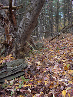
Here is a better picture of the boulder with stones. It's difficult to tell there's a boulder under there. It only shows up from one view:


There was one odd rock between two of the cairns. I was checking carefully between the cairns to be sure I was not mistaking them for a stone wall. Between two of them was this rock:


Here is a close up of the tip of the rock. I don't know if this is natural or man made:


And here is a view of the site, showing where this rock is between the two cairns. It seems to point downhill to the boulder.


This is a pretty view. It's the tributary that runs into the East Branch of Cold Spring Creek (Astraguntira). It's a short distance from the small cairn site to this view of the creek.

Wednesday, December 26, 2007

Small cairn site - Part 3

Some photos of the cairns, or rock piles, trying to show how they are set up in relation to each other.

This is looking north, showing two piles in a row. The third pile to the right is stone on a boulder. Where the row of piles or cairns meet the row of stone (or stone wall), it makes somewhat of a Y with the stone on boulder.


Looking south:


Looking south again, but with the rock piles cleared off, and closer to the pile with the large rock on top.


Both of the photos below are taken from the boulder with the stone on top. The boulder with stone is in the foreground.

In this photo you can see the row of rock piles going off to the south (left in photo):


I cleared the forest debris between the boulder with stone and the line of rock piles to be sure there was no stone row connecting the two.


Then, this view looking downhill. There is a large boulder just below that rock pile, which is visible in the center of this photo.

Monday, December 24, 2007

Bah! Humbug!

It rained last night and, in our yard, about 75% of the snow was gone. I was so excited, I woke up at 3 a.m. waiting to go out and get some great pictures.

There is a huge difference between fields at 1800 ft. and the forest at 2000 ft. The forest still had at least 6 inches of snow everywhere and a thick crust of ice over it. Nevertheless, I took a walk and got a few pictures. Some of them are nice, but I wasn't able to map the grid that I have been longing to see again, without the snow.


This picture is of a rock pile along the upper East Branch of the Cold Spring Creek, where it issues down from the large cairn site and grid in Delaware State Forest. It's one that I've never seen before, so I have no idea what it looks like without the snow. I was using my 4 foot measuring stick again. I seem to have misplaced my half meter stick since the porcupine incident!

I'll be posting a few photos here after I finish posting a few more on the small cairn field from this fall. Merry Christmas and Happy Holidays to everyone!

Friday, December 21, 2007

Small Cairns - part 2

Here are some close up photos of unusual features in some of the small cairns.

This cairn had a piece of wood under the top stone. I have no idea if it was placed there or found it's way under the top stone when the tree branch, that is right next to it, came crashing down (the big branch to the left).


These stones are part of one of the smaller cairns or rock piles, further to the south. Just some unusual features and shapes here.


Tuesday, December 18, 2007

Small cairns

Here are some photos of a small cairn site in Masonville. The row runs roughly north-south on the western side of a hill. This is a hill that, eventually, leads up to the large cairn site in Delaware State Forest.

Two things about these cairns I feel I need to point out. One is that there is a stone row that leads up to the row of cairns, from the north side. I don't know that the stone row is actually a stone wall because it doesn't connect to anything. The stone row is also very low, and about 20 yards long. The other thing is that these cairns, as well as the stone row that leads up to them, were so buried under ferns and forest debris, that I didn't even know they were there until I started being more observant to rocks in the woods.

Here is a picture of part of the stone row that I uncovered. You can faintly see the line between the exposed rocks and the rocks that were covered.


Here are a few photos of some of the cairns. In the first one, my rock pile hunting buddy was climbing on the downed tree just above the cairn.


These 2 are farthest south in the row. They are more like small rock piles instead of cairns. There is also a lot of gravel around these piles.


I'll have more from this site over the next several days.

Saturday, December 15, 2007

Snowed In

We've got quite a bit of snow right now and more is expected tomorrow. I don't know how much I'll be able to post through the winter, if we don't get a thaw between now and April.

I've been seeing some interesting things roadside, and managed to get a few pictures.

On one back road, there is a series of roadside cairns that make up part of a fence. The interesting thing is that, at first, it appears the cairns are part of a stone wall. In one spot, there is a piece of wood, like a fence pole, between cairns. Later down the road, there are just a few cairns with no stone wall and no wood poles in between.

These photos are from the end of the wall where the cairns are attached to the stone wall, and one near where the fence pole was in between. In the third photo, you can see a stone wall in the background that runs up the hill, into the property.


I find roadside cairns confusing. This is because I've seen roadside cairns being constructed by homeowners, so they are obviously not pre-colonial or colonial, but some have an ancient look to them. I believe they could be confused with Native American cairns.

I thought I could use, as a rule of thumb, the fact that roadside cairns are 'in a line' to be able to say that they are recent construction. However, there are small cairns (1 to 3 foot high) that line an abandoned road in Delaware State Forest. They are obviously not recent construction. What is further confusing is that I found a line of similarly built cairns nearby, but not lining any road. Then, there is another line of small cairns I've found, also not lining a road, but their construction is different. They are not as organized. I have some photos of those that I will post here shortly. All of these cairns are located within an approximately 115 acre parcel. If you expand that by about another 100 acres, it would include the large cairn site, and what I believe is a grid, that is in Delaware State Forest. They are all connected.

Thursday, December 6, 2007

Boulder attached to stone wall

Here is the photo of the boulder attached to the stone wall. The stone wall marks a property line between private property and state land, however the state land boundary continues beyond the boulder, where there is no stone wall. Interesting.


You can see the yellow paint on the tree that marks the state land boundary. This is near the site that has the large, rectangular cairns in Melondy Hill State Forest.

I will be without a computer for a little while, so I'll be offline for a few days. I'll post again when I get back on line.

Tuesday, December 4, 2007

Postcard Photo of White Rock

Click the title above for a link to a photo of White Rock, Walton, NY. I'm not sure where this is, or if it still exists today.

Incidentally, if any readers are interested, you can go to the Delaware County, NY website by clicking here. Then click on 'Search This Site' and enter "Indian Trail". It produces 32 hits for the exact phrase and over 200 hits for "find ANY word".