I'm also having a very hard time describing it.
It starts by running perpendicular to a creek branch of the East Branch Cold Spring Creek.
This photo has no rock piles, but gives an overall view of the topography here. The creek branch running left in the photo is the one that the stone row starts at, a bit further up from this view. The runoff to the right is intersected by the stone row.

Walking up the left branch from the photo above, you come to the stone row.

This is following the stone row, perpendicular to the creek branch. The photo here somewhat shows the stone row running to the left, as you look in the background.

Still running perpendicular to the creek branch, the row has a break in it at something like a rock pile. You can see the runoff just behind the rock pile.

I'm having a hard time deciding if the row was modified by someone who needed to get something through there, like a wagon or farm implement - or not. The photo below is my 4 foot walking stick in the break, with the rock pile to the left. I want to say someone piled stones to the left to make the break to the right. But, knowing the area, it doesn't make sense. It's rocky and/or wet here and this stone row does not make any enclosure, so why would someone need to get through it right here?

When I was visiting this area back in February, I thought the break was there for the runoff to flow through, but I've changed my mind about that because there is more runoff coming out from under the stone row, as you can see here.

Then, following the stone row around past the break, it turns and heads in a different direction. I like this photo because it shows the essence of the row, running up and turning a bit, while at the same time keeping the runoff to it's left. Interesting enough, there are 3 rock piles to the right, which I'll get to later, but just in writing this, it has me thinking about a possible reason for the row being a separation between the runoff and the rock piles - pure conjecture.

There is another break in the row at the upper end, now running roughly parallel to the creek branch. But this break has no evidence of rocks being piled to the left or the right.

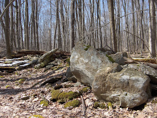
Then, getting toward the upper end of the stone row, there are these interesting rocks. I think I photograph them every time I come out here. There is just something very aesthetically pleasing about them. The last photo of these 3 is a February picture I took of these rocks and I was intrigued with the mountain view in the background.


Where the stone row ends, it has a kind of curvy look to it.

This last picture is looking over the stone row, toward the first of 3 rock piles near the stone row. Actually, it's two rock piles and the third, 'rocks on a boulder'. I'll save those for a separate post.

Yes, that is still snow in the mountain from this past weekend. I thought it was really funny how the snow line seemed to end just over the stone row.
Incidentally, I used the compass to get an idea of the direction of the stone row, and it starts out generally running 135 and ends up running 55. I believe this makes it an obtuse angle.
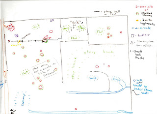
Then, one last thing, I thought I should put some sort of site map out here to give an idea of the location of everything I've been looking at in this area. It is a work in progress, and I have made errors and omissions here and there, so I am not going to swear to the complete accuracy of everything written down here. Also, there are more stone structures on 3 sides (northeast, northwest and southwest) that I haven't been able to fit on this site map, but I've been trying to make up some smaller site maps to add on to this one.

No comments:
Post a Comment